Memorial service for Ric Terman, who protected the boundary stones for decades.
Main Content
The oldest federally-placed monuments in the United States
Boundary Stones of the District of Columbia
In 1790, President George Washington was authorized to select a 100-square-mile site for the national capital. Starting at Jones Point in Alexandria, the diamond-shaped capital was laid out, and boundary stones were set at one-mile intervals in 1971 and 1792.
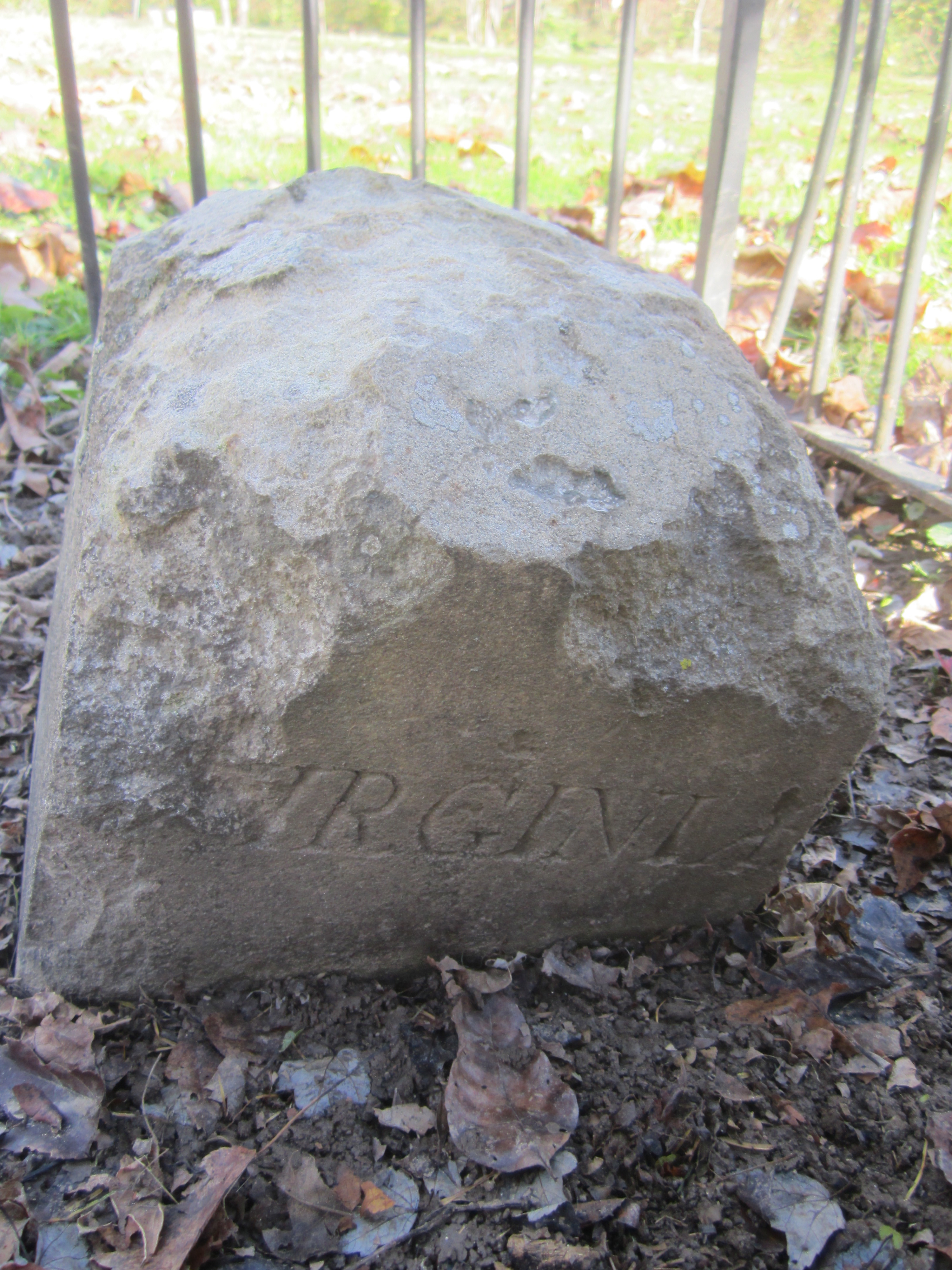
Thirty-six of the original forty stones placed during the Washington Administration are still in or near their original locations.
Interactive Map History News & EventsBoundary Stones Interactive Map
Basic Google Maps Placemarks error: JavaScript and/or CSS files aren't loaded. If you're using do_shortcode() you need to add a filter to your theme first. See the FAQ for details.
Click the map markers above for photos and information about each stone. The DC Geographic Information System's 2011 Survey provided precise GPS data for all existing stones. Two stones were respositioned after the survey, and therefore have approximate coordinates.
Locations with red markers lack stones from the 1790s.
Save to Google Maps Printable ListHistory of the Boundary Stones
Early History
The Residence Act of July 16, 1790, as amended March 3, 1791, authorized President George Washington to select a 100-square-mile site for the national capital on the Potomac River between Alexandria, Virginia, and Williamsport, Maryland. President Washington selected the southernmost location within these limits so that the capital would include all of present-day Old Town Alexandria, then one of the busiest ports in the country. Acting on instructions from Secretary of State Thomas Jefferson, Major Andrew Ellicott began his initial observations for a rough survey of the ten-mile square on Friday, February 11, 1791.
Read On...Growing Public Interest
After Ellicott's team, the next to survey the stones was Marcus Baker, who visited each stone's location during the summer of 1894. Baker reported his survey to the Columbia Historical Society. Following Baker, Fred E. Woodward photographed thirty-nine of the boundary stones--all but SW2, which had been lost even before Baker's survey--starting in 1905. In his reports to the Columbia Historical Society (published in 1907, 1908, and 1915) and in public presentations, Woodward described the extent to which the stones had deteriorated and proposed that they be protected for the enjoyment of future generations. Ernest A. Shuster, Jr., followed in Woodwards's footsteps soon after with his own impressive photo collection and article.
Read On...Subsequent Restoration Efforts
In 1978, Kevin Wood of Boy Scout Troop 98 led a service project that visited most of the stones to clean up the sites and repaint the fences.
In 1990 and 1991, a resurveying team led by David Doyle to celebrate the District's bicentennial located two missing stones. In September 1995, the Northern Virginia Boundary Stones Committee (NOVABOSTCO), under the leadership of chairman Ric Terman, issued a 77-page report on the status of the fourteen stones in Virginia.
Read On...News & Events
See AllBoundary Stones: The Quest to Save DC’s 1st federal monuments
A nice article on WTOP’s website about the history of the Boundary Stones.
Fifth Annual Boundary Stone Ride
On October 14th, join us for the annual bike ride around the oldest federal monuments, the DC Boundary stones.